Martin Lawrence Photography
The lost village of Mardale Green at Haweswater
Posted on 13th July, 2018

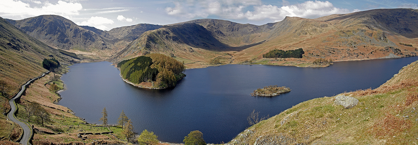
Image 1: Haweswater from the Old Corpse Road to Swindale - the reservoir here is at it's normal level
After the long dry period we have been experiencing recently, we decided to take a trip to Haweswater in the Mardale Valley to see if the submerged village of Mardale Green had started to re-appear.
The controversial construction of the Haweswater dam was started in 1929, after Parliament passed an Act giving Manchester Corporation permission to build the reservoir to supply water to the northwest of England. There was a great public outcry at the time as the farming villages of Measand and Mardale Green lay in the valley. Construction of the reservoir would mean that these villages would be flooded and the population evicted. The valley was considered to be one of the most picturesque in Westmorland, and many people thought it should be left as it was. But the project went ahead and the villages were submerged in 1935.
The Royal Engineers demolished all the farms and houses in the villages of Mardale and Measand including Holy Trinity Church and the Dun Bull Inn. Coffins were removed from the graveyard, and buried elsewhere. A dam was built at the northern end of the valley raising the water level of the original lakes of High and Low Water by 95 feet to create a reservoir 4 miles long and half a mile wide.

Image 2: Haweswater from the Old Corpse Road to Swindale taken on 9th July 2018 showing the current water level
We parked in the car park at the head of the Mardale Valley underneath Harter Fell and were able to walk along the valley floor on the old road, bordered by tumbled down walls, which used to lead through Mardale Green passed the Dun Bull Inn, into Riggindale and on up the valley on the western side of the now reservoir. This area is usually filled with water. You could clearly see the remains of many of the old buildings, stone gateposts and tree stumps. More ruins lay just below the surface of the water ready to appear. I found it really sad to think that people living a rural life in such an idyllic place could have everything suddenly snatched away from them.


Images 3 and 4: The old valley road through Mardale Green that led past the Dunn Bull Hotel taken on 9th July 2018

Image 5: The ruins of Bracken Howe Farm taken on 9th July 2018
We then climbed steeply up the side of the reservoir (not recommended) beside the ruins of Bracken Howe Farm to join the footpath that goes across the Rigg and down into Riggindale where more ruins were visible. This is the site of Chapel Hill Farm and Riggindale Farm and a great area for photographic explorations. There are fablous views in every direction using the ruins as a foreground.
It was just about possible currently to walk back to the head of the valley past Holy Trinity Church ruins on the stony reservoir edge but it is very rough.


Image 6 and 7: Ruins in the Riggindale area of Chapel Hill Farm and Riggindale Farm taken on 9th July 2018

Image 8: Riggindale area with the reservoir at its normal level
This is an image taken a couple of years back showing the usual water level in the Riggindale area. If the drought were to contune, the whole of this bay would dry up to expose more buildings and a couple of bridges.
We spoke to a park ranger who told us that the level of the reservoir was currently falling by seven inches a day and that, if that rate continued, the whole of the village would be visible in about five weeks time. That is, of course, unless we have some decent rainfall. I’ve made a note I my diary to return if the weather conditions don’t change. I have witnessed this before and it really is something not to be missed despite the huge traffic jam that it causes.
If you would like to purchase any of these images please visit the Ullswater and Haweswater Gallery where you can find most of them. If an image you want isn't there, just e-mail me and I can supply this for you.
Sheila Lawrence
© Martin Lawrence Photography 2018
